


Sarasota Red Snapper Fishing Spots – GPS Numbers (Up to 922 Spots)
Sarasota Red Snapper Fishing Spots – GPS Numbers (Up to 922 Spots)
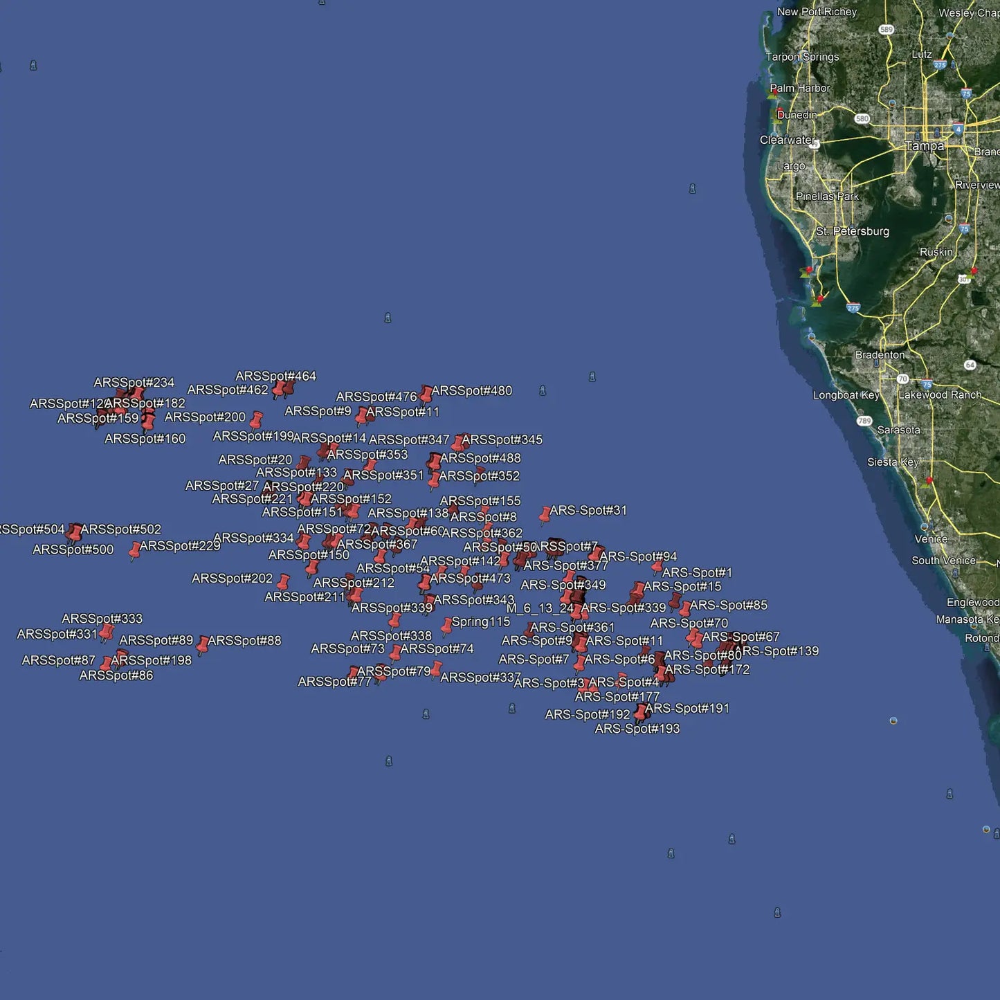
Explore the Best Sarasota Red Snapper Fishing Spots with GPS Coordinates
Stop searching. Start catching. Our exclusive 2026 Sarasota Red Snapper fishing spots package gives you access to up to 922 premium, never-before-released waypoints — from shallow ledges to deep-water boulders and pinnacles where the biggest American Red Snapper (ARS) stack up. This package will cover Anna Maria Island south to Venice
Choose the package that fits your boat and your ambition:
Option 1 – Premium Shallow Package – 407 Spots
- 407 exclusive GPS waypoints in 120–160 feet of water
- Ledges and rocky hard bottom — classic ARS territory
- Perfect for anglers targeting the federal snapper season opener
Option 2 – Extreme Deep Package – 515 Spots + 10 Routes
- 515 deep-water GPS waypoints from 160 to nearly 600 feet
- Massive boulders and pinnacles past 300 ft — where the true stud ARS live
- 10 exclusive routes designed to surround large hard bottom areas and sinkholes — appear as tracks on your plotter for systematic coverage
- Routes range from a few acres to several square miles
Option 3 – Complete Bundle – 922 Spots + 10 Routes (Save 15%)
- Everything in Options 1 & 2 combined
- Best value — save 15% vs. buying separately
- The ultimate Red Snapper arsenal for Sarasota and Venice offshore anglers
Pro Tip: Red Snapper Move — A Lot
Don't get discouraged if the first spot is quiet. ARS are nomadic and may require working through several waypoints before you find the school. When you do? Get ready for a serious tug-of-war with one of the Gulf's most hard-fighting reef fish.
Compatible With All Major Chart Plotters & Apps
Works seamlessly with Garmin, Simrad, Lowrance, Raymarine, B&G, Humminbird, and Furuno MFDs, plus mobile apps including Active Captain, Navionics, Aquamaps, Base Camp, GPX Studio, and Google Earth. If it runs GPS mapping software, it works.
Download. Load. Drop Lines. Get on the water with the confidence of knowing exactly where to go.
Our files are sold as either digital downloads or delivery via SD Card. If you need an SD card shipped to your door, select the Yes Option for SD Card Delivery. If you order an SD card you will not receive a download link. Our shipping options include Ground UPS, Second day or Next Day Air Options. We also have FedEx available.
For other plotter types, choose Garmin. GPX compatibility is expected.
Package Price
Discount available for our heroes. Military, First Responders, Medical Workers and Teachers qualify for 20% off at checkout. Our Way of saying thank you!
Couldn't load pickup availability