


Bay St. Louis Fishing Spots - GPS Fishing Numbers
Bay St. Louis Fishing Spots - GPS Fishing Numbers
Bay St. Louis Fishing Spots Guide for Better Trips
This extensive package includes more than 1300 Bay St. Louis fishing spots along the Alabama-Mississippi-Louisiana coastline to approximately 30 miles offshore. Spots range from Mobile Bay in the east to Biloxi, MS, in the west.
Anglers can confidently cast their lines on our spots and reel in a diverse array of sought-after coastal species, including but not limited to Snook, Redfish, Black Drum, Black Seabass, Snappers, and Grunts.
Compatible with Garmin, Simrad, Lowrance, Raymarine, B&G, Humminbird and Furono MFDs. Also, the apps from those manufacturers, Any mobile device or tablet running GPS Mapping software like Active Captain, Navionics, Aquamaps, Base Camp, GPX Studio, Google Earth, and many others.
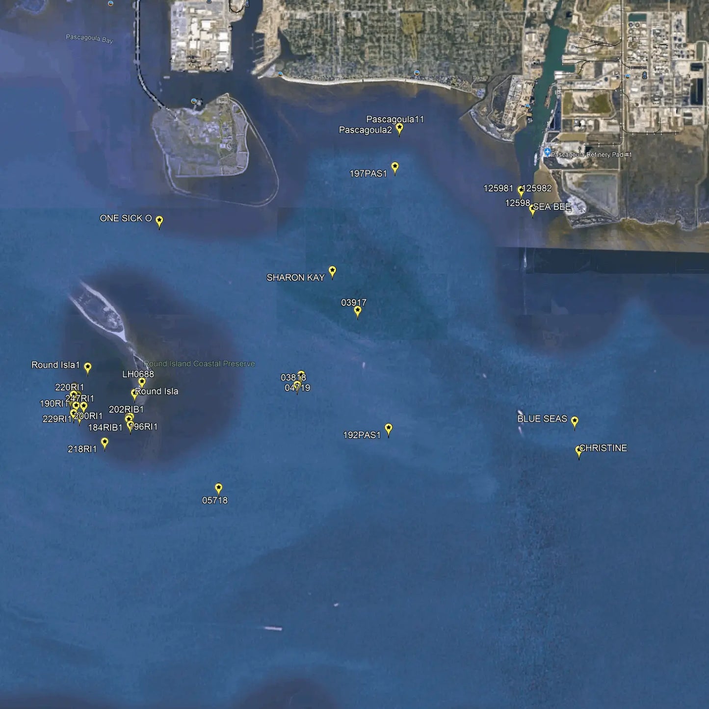
Find Productive Waters with Confidence
Explore Bay St. Louis fishing spots with GPS fishing numbers designed to help anglers reach productive water faster. Instead of guessing where to cast, you can use precise location data to target proven areas around Bay St. Louis, Mississippi. This product is built for fishermen who want more time fishing and less time searching. Whether you prefer shoreline, pier, kayak, or boat fishing, these fishing numbers make planning easier and more efficient. It is a practical tool for anglers looking to improve trip success with reliable, easy-to-use information.
Target a Variety of Saltwater Species
Bay St. Louis offers a strong mix of inshore fishing opportunities, and this product helps you focus on the spots where fish are most likely to hold. The GPS fishing numbers can guide you toward areas that may produce redfish, speckled trout, flounder, and other local saltwater species. By narrowing your search to known fishing locations, you can fish with more purpose and better timing. This makes the product useful for both experienced anglers and beginners who want a dependable starting point. It is a smart way to fish the Bay St. Louis area with greater confidence.
Easy to Use for Planning and Navigation
These Bay St. Louis fishing spots are organized to support simple trip planning and quick navigation. Anglers can load the GPS fishing numbers into their devices and head directly to the water with less stress. This saves valuable fishing time and helps you stay focused on conditions, tides, and bait presentation. The product is especially helpful when exploring a new area or when you want to avoid spending a full day searching for structure and fish-holding zones. Clear, accurate location details make it easier to build a better fishing plan before you leave home.
A Practical Resource for Local and Visiting Anglers
Whether you live nearby or are visiting the Mississippi coast, this product gives you a practical edge on the water. Bay St. Louis fishing spots can change with weather, tide movement, and seasonal fish patterns, so having GPS fishing numbers is a valuable advantage. The product helps reduce uncertainty and gives anglers a more efficient way to locate promising water in a well-known Gulf Coast fishing destination. It is ideal for anyone who wants a straightforward, location-based fishing tool that supports better decisions, improved coverage, and a more productive day on the water.
Our files are sold as either digital downloads or delivery via SD Card. If you need an SD card shipped to your door, select the Yes Option for SD Card Delivery. If you order an SD card you will not receive a download link. Our shipping options include Ground UPS, Second day or Next Day Air Options. We also have FedEx available.
For other plotter types, choose Garmin. GPX compatibility is expected.
Package Price
Discount available for our heroes. Military, First Responders, Medical Workers and Teachers qualify for 20% off at checkout. Our Way of saying thank you!
Couldn't load pickup availability